Birmingham, February 5, 2026
Birmingham and nearby areas are currently under a Tornado Watch due to severe weather threats including high risks for tornadoes, damaging winds, and large hail. Residents are urged to stay informed and prepared as the situation may evolve rapidly. With potential wind speeds reaching up to 80 mph in some regions, emergency services are on high alert, encouraging the community to adhere to safety protocols and secure their properties against the incoming storms.
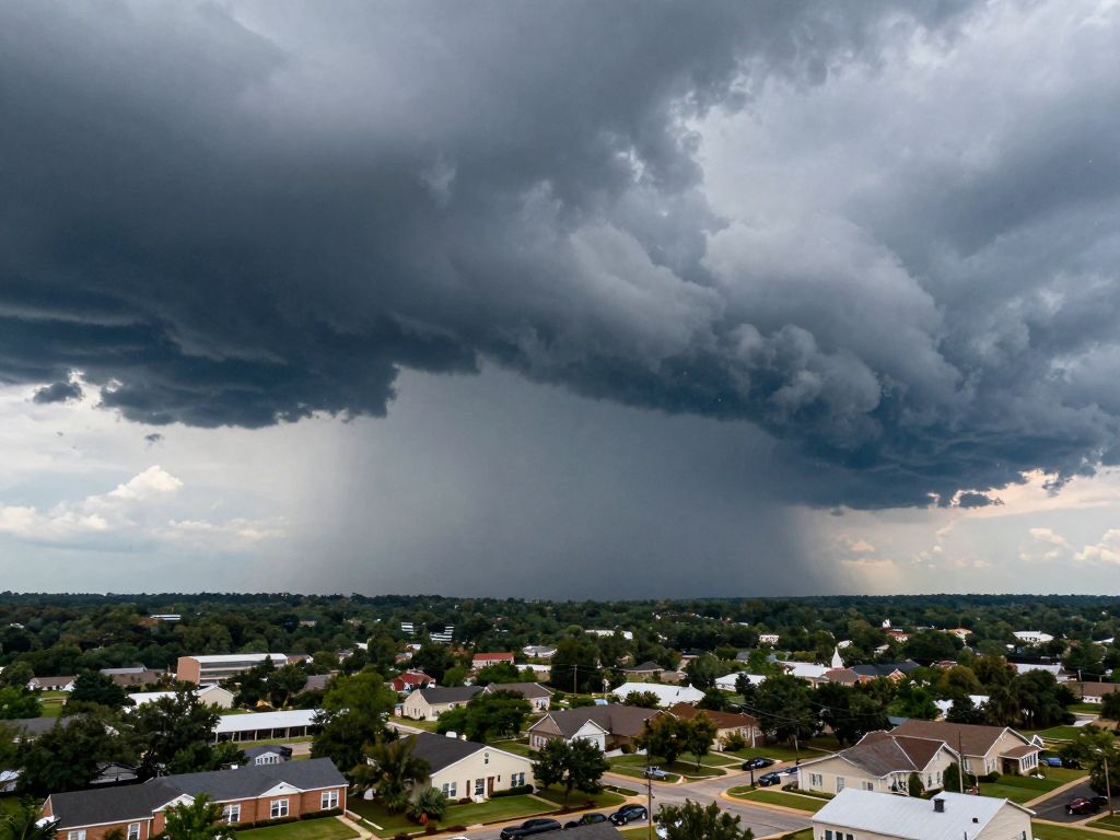
Birmingham, Alabama Braces for Severe Storms with High Tornado and Damaging Wind Risk
Birmingham, Alabama, and its surrounding communities are currently facing a significant and intensifying weather threat, with a Tornado Watch in effect across the region. Residents are under a high risk for tornadoes and the potential for extensive damaging winds, alongside the threat of large hail. These hazardous conditions are expected to persist throughout the night, prompting urgent calls for preparedness and vigilance from weather authorities and emergency services.
Immediate Threat and Widespread Impact
The severe weather system is rapidly intensifying and spreading across Alabama, indicating a widespread and dangerous situation. The Tornado Watch extends beyond Birmingham, encompassing a range of communities including Moody, Montevallo, Hueytown, and Tarrant. For residents in these areas, the threat is immediate, demanding that they stay continuously updated with official weather alerts and ensure they have a designated safe place to seek shelter. The dynamic nature of these storms means conditions can change rapidly, emphasizing the need for constant awareness and readiness.
A primary concern highlighted by meteorologists is the potential for not only tornadoes, which can develop quickly and cause catastrophic damage, but also exceptionally strong straight-line winds. These winds, separate from tornadoes, can be equally destructive. Forecasts for areas like Huntsville have indicated potential wind speeds of up to 80 mph. Such powerful winds can cause significant structural damage to homes and businesses, easily uproot mature trees, and turn ordinary outdoor objects into dangerous projectiles. Such powerful gusts can also lead to widespread and prolonged power outages, impacting thousands of residents and disrupting daily life and emergency services.
Understanding the “High Risk” Designation and Necessary Preparations
The designation of a “high risk” for severe weather is not given lightly; it signifies an exceptional threat level where widespread significant severe weather events, including strong tornadoes and very damaging winds, are considered probable. This elevates the urgency for all residents within the watch area to take proactive steps to protect themselves and their property. The storms are not just limited to wind and tornadoes; they are also bringing a heightened risk of large hail. Hailstones, particularly large ones, can cause considerable damage to vehicles, shatter windows, damage roofs, and devastate agricultural crops. The combined impact of these multiple threats necessitates immediate and serious attention from all individuals in the path of the storm.
Authorities are actively engaged in monitoring the intricate progression of these weather systems, advising the public to maintain constant vigilance. Essential safety measures include ensuring access to multiple reliable sources for severe weather alerts, such as NOAA weather radios, emergency alerts on mobile devices, and local news broadcasts. Families are strongly advised to review and practice their emergency plans, identifying the safest interior room in their home—preferably a basement or an interior room on the lowest floor away from windows—or knowing the location of the nearest community storm shelter. It is also crucial to secure or bring indoors any outdoor furniture, trash cans, or other loose items that could be picked up by high winds and cause further damage or injury. Ignoring these warnings could have serious consequences, given the high-risk nature of the forecasted conditions.
Regional Context and Emergency Response Efforts
Alabama, situated in a region frequently affected by severe weather, experiences such intense storm systems with regularity, making preparedness an ongoing necessity. The current weather event serves as a critical reminder of the destructive potential of nature. Emergency services across the state are on high alert, with plans in place for rapid deployment to address potential emergencies, conduct search and rescue operations, clear debris, and work towards restoring critical infrastructure like power. The effectiveness of these response efforts is significantly bolstered by public cooperation and adherence to safety directives.
The continuous flow of information from weather agencies underscores the dynamic nature of this severe weather outbreak. Residents are urged to remain indoors and off the roads during the peak intensity of the storms, whenever possible, to avoid putting themselves or emergency personnel at additional risk. Prioritizing personal safety and the well-being of family members, pets, and neighbors is paramount during these critical hours as the severe weather system progresses across Alabama. The collective community effort in staying informed and taking preventive actions will be crucial in mitigating the overall impact of this significant weather event.
Frequently Asked Questions
What is the current weather alert for Birmingham, Alabama?
Birmingham, Alabama, and surrounding communities are currently under a Tornado Watch.
What are the primary threats associated with these storms?
Residents face a high risk for tornadoes, significant damaging winds, and large hail.
Which other areas in Alabama are impacted by this severe weather?
The Tornado Watch encompasses a broad area, including municipalities such as Moody, Montevallo, Hueytown, and Tarrant.
What wind speeds are expected in some areas?
Forecasts for areas like Huntsville have indicated potential wind speeds of up to 80 mph.
What is the significance of a “high risk” designation for severe weather?
A “high risk” for severe weather signifies an exceptional threat level where widespread significant severe weather events, including strong tornadoes and very damaging winds, are considered probable.
What safety measures are advised for residents?
Essential safety measures include ensuring access to multiple reliable sources for severe weather alerts, reviewing and practicing emergency plans, identifying the safest interior room in their home or nearest community shelter, and securing outdoor items.
Key Features of the Severe Weather Event in Alabama
| Feature | Description | Geographic Scope |
|---|---|---|
| Primary Alert | Tornado Watch | State-level (Birmingham and surrounding communities) |
| Risk Level | High Risk for severe weather events | State-level |
| Main Threats | Tornadoes, Damaging Winds, Large Hail | State-level |
| Affected Cities (Specific) | Birmingham, Moody, Montevallo, Hueytown, Tarrant, Huntsville | Local (within State-level event) |
| Maximum Wind Speeds | Up to 80 mph (in areas like Huntsville) | Local (within State-level event) |
| Duration | Expected to persist through the night | State-level |
Deeper Dive: News & Info About This Topic
HERE Resources
Tragic End to Search for Birmingham Cousins
Birmingham Home Show 2026: Design for a Thriving Community
Central Alabama Faces Extreme Cold and Wind Chills
Fatal Crash on Interstate 20 Claims Life of Pell City Man
Tragic Vehicle Crash Claims Life of 70-Year-Old Woman in Shelby County
Mountain Brook Embraces Community Engagement this February
Birmingham Community Honors Nurse Alex Pretti
Birmingham’s February: Free Events & Community Spirit Thrive
Birmingham Reports Major Developments in Economy, Healthcare and Community
Arctic Chill Descends: Snow Showers Expected Across Alabama
Author: STAFF HERE BIRMINGHAM WRITER
The BIRMINGHAM STAFF WRITER represents the experienced team at HEREBirmingham.com, your go-to source for actionable local news and information in Birmingham, Jefferson County, and beyond. Specializing in "news you can use," we cover essential topics like product reviews for personal and business needs, local business directories, politics, real estate trends, neighborhood insights, and state news affecting the area—with deep expertise drawn from years of dedicated reporting and strong community input, including local press releases and business updates. We deliver top reporting on high-value events such as the Sidewalk Film Festival, Sloss Music & Arts Festival, Magic City Classic, and civil rights commemorations. Our coverage extends to key organizations like the Birmingham Business Alliance and the Birmingham Civil Rights Institute, plus leading businesses in healthcare, finance, and manufacturing that power the local economy such as UAB Medicine, Regions Bank, and Encompass Health. As part of the broader HERE network, including HEREHuntsville.com, we provide comprehensive, credible insights into Alabama's dynamic landscape.