Birmingham, Alabama, January 10, 2026
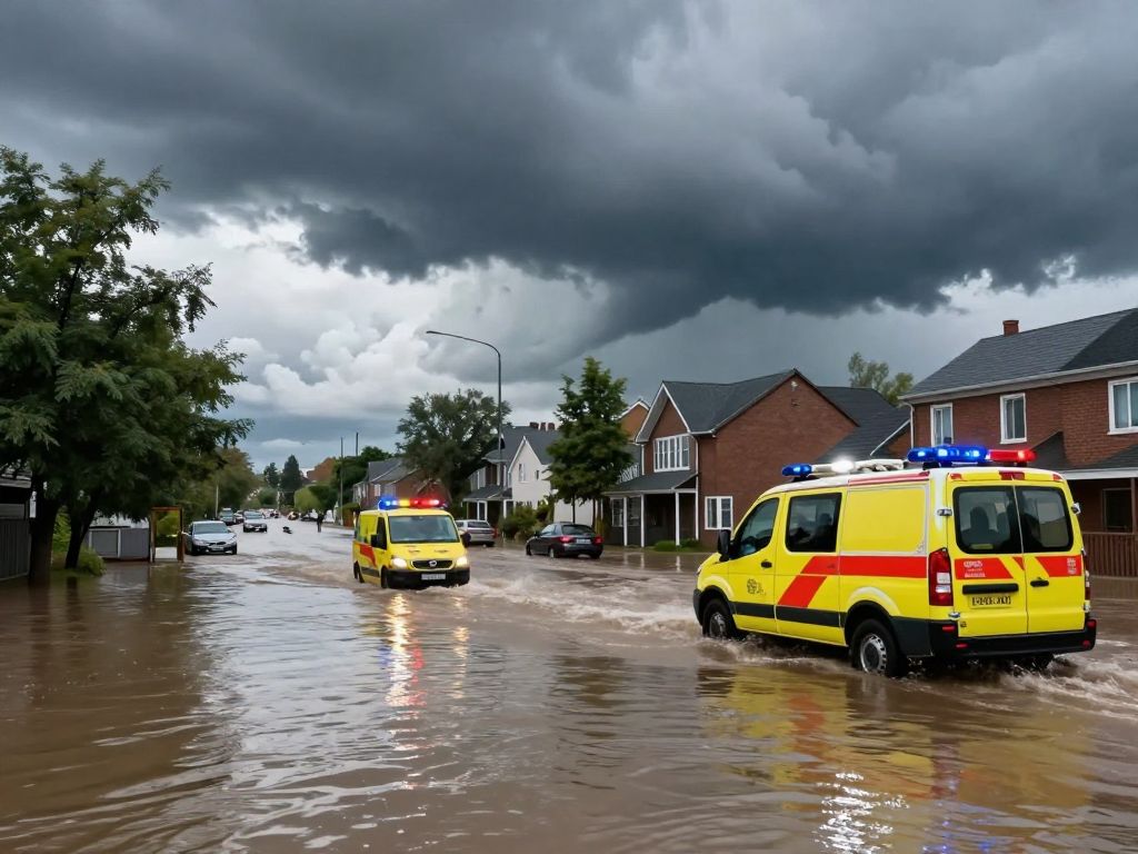
Central Alabama is facing significant flooding and severe weather threats due to heavy rainfall over a 48-hour period. The National Weather Service has issued flood watches for multiple counties, warning of flash flooding, dangerous road conditions, and the potential for severe storms including damaging winds and isolated hail. Residents are urged to stay informed and exercise caution, particularly when driving in flooded areas. As the situation evolves, emergency agencies emphasize awareness and safety measures.
Birmingham, Alabama
Central Alabama has experienced a significant period of heavy rainfall and severe weather threats over the last 48 hours, prompting widespread flood watches and advisories across the region. The conditions, which began on Friday morning, January 9, 2026, and continued through Saturday morning, January 10, 2026, have created a risk of impassable roads, water rescues, and traffic incidents due to excessive runoff.
Widespread Flood Watches and Heavy Rainfall
A Flood Watch was issued by the National Weather Service (NWS) Birmingham, Alabama, effective from Thursday, January 8, 2026, at 11:53 AM CST until Saturday, January 10, 2026, at 12:00 PM CST. This watch covered a large portion of Central Alabama, encompassing numerous counties. These included Autauga, Bibb, Blount, Calhoun, Chambers, Cherokee, Chilton, Clay, Cleburne, Coosa, Dallas, Elmore, Etowah, Fayette, Greene, Hale, Jefferson, Lamar, Marengo, Marion, Perry, Pickens, Randolph, Shelby, St. Clair, Sumter, Talladega, Tallapoosa, Tuscaloosa, Walker, and Winston counties.
Northern Alabama also faced similar conditions, with NWS Huntsville issuing a Flood Watch for counties such as Lauderdale, Colbert, Franklin, Lawrence, Limestone, Madison, Morgan, Marshall, Jackson, DeKalb, and Cullman, extending into southern middle Tennessee. Forecasts indicated that two to four inches of rainfall were expected across much of the watch areas, with some localized regions potentially receiving more than five inches.
Potential for Significant Impacts
The excessive rainfall was expected to lead to flash flooding, particularly in low-lying and flood-prone areas, including rivers, creeks, and streams. Urban areas and locations with poor drainage were also susceptible to flooding. The Alabama Emergency Management Agency highlighted concerns that flooding rainfall could exceed four inches by Saturday afternoon. Such conditions can quickly render roads impassable, necessitate water rescue operations, and contribute to vehicle crashes. Drivers across the state were urged to exercise extreme caution.
Concurrent Severe Weather Threats
In addition to flooding, the weather system brought a threat of severe storms to Central Alabama. Meteorologists closely monitored the situation for potential damaging wind gusts, isolated hail, and the possibility of a few tornadoes. The severe weather potential was a significant concern from Friday morning into early Saturday, with some uncertainty surrounding the development of instability due to extensive cloud cover and existing rainfall. The severe threat was anticipated to subside in the southeastern sections of the state by Saturday evening.
Specific attention was drawn to areas like Ardmore in Limestone County, where rising water levels prompted warnings about potential worsening conditions. Historically, underpasses in Ardmore, such as the one on Main Street, have experienced severe flooding, submerging vehicles and requiring swift water rescues. As of January 9, 2026, no road closures had been implemented in Ardmore, but local authorities were actively monitoring the situation.
Safety Recommendations and Ongoing Monitoring
Emergency management agencies across Alabama emphasized critical safety messages throughout the severe weather event. Residents were advised to stay informed by monitoring the latest weather forecasts and to be prepared to take immediate action if Flash Flood Warnings were issued for their specific locations. A key directive was to never attempt to drive through flooded roads, especially during nighttime hours, as the depth of water can be deceptive. Warnings highlighted that as little as 18 inches of standing water, or even less, can cause a vehicle to lose contact with the road, leading to it being swept away if the water is moving rapidly. Motorists were strongly encouraged to utilize main roads and interstates rather than less maintained county roads, which are more prone to flooding and washouts.
The Alabama Department of Transportation (ALDOT) provided resources such as ALGOtraffic.com and the ALGO Traffic app for live traffic updates and road conditions, reminding drivers to use these tools responsibly and avoid mobile device usage while driving.
Weather System Overview
The adverse weather was attributed to heavy rainfall entering the state from Thursday night into Friday morning, with a frontal boundary becoming a focal point for both severe weather and very heavy rainfall across western and central Alabama. While there might have been a brief lull in severe weather for the northern half of the state on Friday evening, increased wind shear overnight was expected to contribute to the redevelopment of severe storms into Saturday morning. The southern half of Alabama had a longer window for severe weather potential, although not continuously. After 6 AM CST on Saturday, severe weather was expected to become isolated as the main upper-level support moved away from the state.
Frequently Asked Questions (FAQ)
- What areas in Alabama were affected by the recent severe weather and flooding? (State-level)
- A large portion of Central Alabama was under a Flood Watch, including Autauga, Bibb, Blount, Calhoun, Chambers, Cherokee, Chilton, Clay, Cleburne, Coosa, Dallas, Elmore, Etowah, Fayette, Greene, Hale, Jefferson, Lamar, Marengo, Marion, Perry, Pickens, Randolph, Shelby, St. Clair, Sumter, Talladega, Tallapoosa, Tuscaloosa, Walker, and Winston counties. Northern Alabama, including Lauderdale, Colbert, Franklin, Lawrence, Limestone, Madison, Morgan, Marshall, Jackson, DeKalb, and Cullman counties, also faced flood watches.
- When did the Flood Watch for Central Alabama expire? (State-level)
- The Flood Watch issued by NWS Birmingham, Alabama, for Central Alabama expired on Saturday, January 10, 2026, at 12:00 PM CST.
- What were the expected rainfall amounts in the affected areas? (State-level)
- Two to four inches of rainfall were forecast across much of the watch area, with some localized regions potentially receiving more than five inches.
- What were the main risks associated with the severe weather? (State-level)
- The main risks included flash flooding caused by excessive rainfall, damaging wind gusts, isolated hail, and a few tornadoes.
- What safety advice was provided regarding driving in flooded conditions? (State-level)
- Residents were advised to never drive into flooded roads, especially at night, as 18 inches or less of standing water can cause a vehicle to lose contact with the road. Motorists were also urged to stick to main roads and interstates.
Key Features of the Central Alabama Severe Weather Event
| Feature | Description | Geographic Scope |
|---|---|---|
| Primary Event Type | Heavy rainfall and potential flash flooding | State-level (Central & Northern Alabama) |
| Severe Weather Threats | Damaging wind gusts, isolated hail, and a few tornadoes possible | State-level (Central & Southern Alabama) |
| Flood Watch Period | January 8, 2026, 11:53 AM CST until January 10, 2026, 12:00 PM CST | State-level (Central Alabama) |
| Expected Rainfall | 2-4 inches widespread, with local amounts exceeding 5 inches | State-level (Central & Northern Alabama) |
| Primary Impacts | Flooding of rivers, creeks, streams, low-lying, poor drainage, and urban areas | State-level (Central & Northern Alabama) |
| Driving Safety Advisory | Never drive through flooded roads; 18 inches or less of water can cause loss of control. Stick to main roads. | State-level (Nationwide advisory for safe driving, specifically applied to Alabama conditions) |
Deeper Dive: News & Info About This Topic
HERE Resources
Birmingham’s Jimmie Hale Mission Plans New Emergency Shelter
Natural Bridge Park Reopens to Visitors in Birmingham
Severe Thunderstorm Warning for Chambers and Lee Counties
Dauphin Island Faces Existential Crisis After Katrina
Birmingham Community Mourns the Loss of Coach Beverly
Birmingham Secures Airport Lease Extension for Aviation Growth
Birmingham Police Investigate Suspicious Deaths
Birmingham Metro Area Weather Alert and School Rankings Released
Birmingham Public Library Launches Health and Wellness Programs
Birmingham Public Library to Offer Free Health & Self-Care Programs
Author: STAFF HERE BIRMINGHAM WRITER
The BIRMINGHAM STAFF WRITER represents the experienced team at HEREBirmingham.com, your go-to source for actionable local news and information in Birmingham, Jefferson County, and beyond. Specializing in "news you can use," we cover essential topics like product reviews for personal and business needs, local business directories, politics, real estate trends, neighborhood insights, and state news affecting the area—with deep expertise drawn from years of dedicated reporting and strong community input, including local press releases and business updates. We deliver top reporting on high-value events such as the Sidewalk Film Festival, Sloss Music & Arts Festival, Magic City Classic, and civil rights commemorations. Our coverage extends to key organizations like the Birmingham Business Alliance and the Birmingham Civil Rights Institute, plus leading businesses in healthcare, finance, and manufacturing that power the local economy such as UAB Medicine, Regions Bank, and Encompass Health. As part of the broader HERE network, including HEREHuntsville.com, we provide comprehensive, credible insights into Alabama's dynamic landscape.